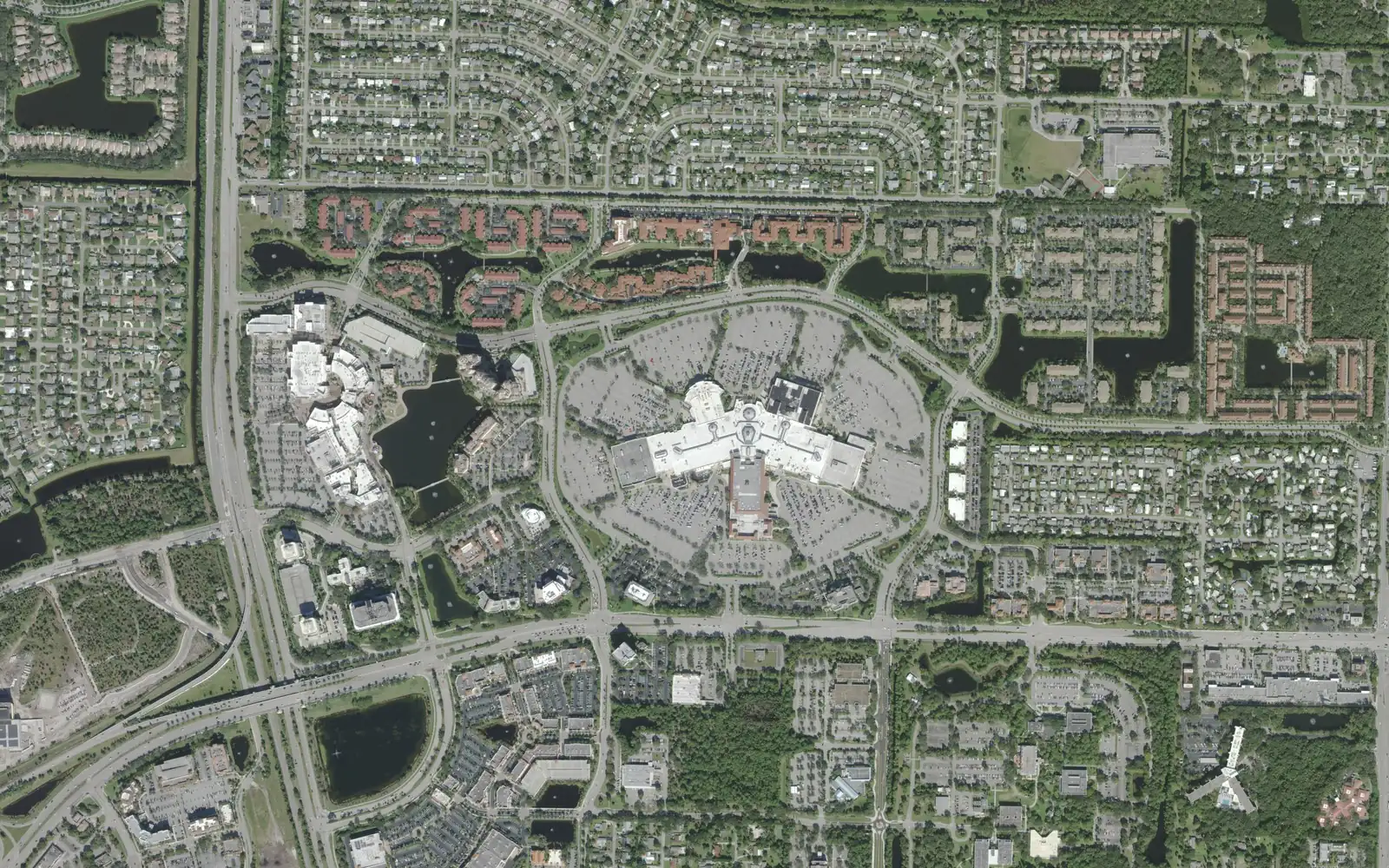
The Regional Center around the Gardens Mall and PGA Boulevard holds about 3,100 homes, most of them condos, all in ZIP code 33410.
Last checked Oct. 10, 2026. Sources: the City of Palm Beach Gardens’ GIS subdivision, neighborhood, overlay and address layers and its Comprehensive Plan, Palm Beach County’s school zone open data, the Florida Department of Education’s 2026 school grades, the Zillow Home Value Index (Zillow Research), Palm Tran and © OpenStreetMap contributors.
The Regional Center is the name the city’s subdivision layer gives the 452-acre district around the Gardens Mall and Downtown at the Gardens, on the north side of PGA Boulevard. With the condo communities just south of PGA Boulevard near I-95, it is the closest thing Palm Beach Gardens has to a downtown neighborhood: about 3,100 residential addresses on the city’s address layer, all in ZIP code 33410, most of them condos.
What this means for you
- High school: William T. Dwyer High for the Regional Center (58% of homes, grade A in 2026); Palm Beach Gardens High south of PGA Boulevard (grade C).
- Home value: $589,714 in ZIP code 33410 in August 2026, according to the Zillow Home Value Index.
- Nearest highway exit: I-95 exit 79 (PGA Boulevard), about 1.2 miles by road.
Part of our Palm Beach Gardens neighborhoods guide. For shopping, dining and events, see our guide to downtown Palm Beach Gardens.
Where it is
The area runs along PGA Boulevard from I-95 east toward Prosperity Farms Road. North of PGA Boulevard, the Regional Center takes in the mall, Downtown at the Gardens, Lake Victoria Gardens Avenue, Kyoto Gardens Drive and Gardens Parkway, and the city’s layer names 19 neighborhoods inside it. South of PGA Boulevard, this page also covers Legacy Place (74 acres, about 390 condos), PGA Station and Everleigh, an assisted living community.
Two planning tools from the city’s future land use element (PDF) apply here. The PGA Boulevard Corridor Overlay treats PGA Boulevard as the city’s “main street,” and the city’s GIS maps a Transit Oriented Development District around the corridor.
On the city’s address layer, 62% of the area’s residential addresses are condos, 14% are assisted living units, 11% are apartments and 10% are townhouses. The city marks about half as inside a gated community.
Schools
From Palm Beach County’s open data copy of the School District of Palm Beach County’s attendance zones, matched to every residential address:
| Level | Zoned school | Where | Florida 2026 grade |
|---|---|---|---|
| Elementary | Dwight D. Eisenhower K-8 | Regional Center (58%) | A |
| Elementary | Palm Beach Gardens Elementary | PGA Station (23%) | A |
| Elementary | Allamanda Elementary | Legacy Place, Everleigh (19%) | A |
| Middle | Howell L. Watkins Middle | All | C |
| High | William T. Dwyer High | Regional Center (58%) | A |
| High | Palm Beach Gardens High | South of PGA Boulevard (42%) | C |
Each name links to the school’s state report card. Because the area is split, check every address on the district’s Find My School map. More in our schools guide.
Home values
The typical home value in ZIP code 33410 was $589,714 in August 2026, up 2.8% from $573,575 in August 2025. Zillow’s figure for Palm Beach Gardens as a whole was $695,799, up 3.2%. The Zillow Home Value Index is a modeled typical value for the middle third of homes, single-family houses and condos together, not a sale price, and it covers the whole ZIP code, which runs from Northlake Boulevard to Donald Ross Road east of I-95. More in our home prices guide.
Parks and trails
The city’s park layer shows no city park inside the Regional Center. The nearest are Oaks Park, 10666 Gardens East Drive, south of PGA Boulevard, with a 0.65-mile walking trail and two tennis courts, and the Riverside Youth Enrichment Center on Ruby Street. More in our parks and trails guide.
Getting around
- I-95: exit 79 (PGA Boulevard), about 1.2 miles by road; exit 77 (Northlake Boulevard), about 4.2 miles.
- Florida’s Turnpike: exit 109 (PGA Boulevard), about 2.9 miles.
- City Hall (10500 N. Military Trail): about 1.9 miles.
- President Donald J. Trump International Airport (PBI): about 13 miles.
- These are distances measured on the OpenStreetMap road network with the OSRM routing engine from the middle of the area, not drive times.
- Bus: the Gardens Mall is the end of the line for four Palm Tran routes, according to its current schedule data: Route 1 (U.S. 1 to Boca Raton), Route 3 (Military Trail to Boca Raton), Route 10 (Military Trail to Jupiter) and Route 33 (to Cross County Plaza via Palm Beach Lakes Boulevard and Australian Avenue).
More in our getting around guide.
Groceries and everyday stores
OpenStreetMap lists a Whole Foods Market at 11701 Lake Victoria Gardens Ave., about half a mile by road from the middle of the area. Trader Joe’s at 2560 PGA Blvd. is about 1.4 miles east, and the Publix at 10913 N. Military Trail and CVS Pharmacy at 11000 N. Military Trail are about 1.6 miles west.
How we drew this area
This page follows the Regional Center boundary in the City of Palm Beach Gardens’ subdivision layer, plus the residential neighborhoods inside the city’s Transit Oriented Development District layer south of PGA Boulevard (Legacy Place, PGA Station and Everleigh). Home counts, home types, gates and ZIP codes come from the city’s address layer on Oct. 10, 2026, counting residential addresses, which include assisted living units. Each address was matched to Palm Beach County’s open data copy of the district’s attendance zones. Store locations and road distances use © OpenStreetMap contributors.
Frequently asked questions
What is the Regional Center in Palm Beach Gardens?
The name the City of Palm Beach Gardens’ subdivision layer gives the 452-acre district around the Gardens Mall and Downtown at the Gardens. With Legacy Place and the condos at PGA Boulevard and I-95, it holds about 3,100 residential addresses.
What high school is the Gardens Mall area zoned for?
The Regional Center itself is zoned for William T. Dwyer High; Legacy Place, PGA Station and Everleigh, south of PGA Boulevard, are zoned for Palm Beach Gardens High, in Palm Beach County’s copy of the district’s zones.
Is the Regional Center a good place to live?
Here are the facts. The area has about 3,100 homes, 62% of them condos, a Whole Foods Market, and stops on four Palm Tran routes that start at the Gardens Mall. The typical home value in ZIP code 33410 was $589,714 in August 2026, according to Zillow.
Which Palm Tran buses go to the Gardens Mall?
Routes 1, 3, 10 and 33 all start or end at the Gardens Mall, according to Palm Tran’s current schedule data.
Have your say