Palm Beach Gardens' 39,000 homes in 12 areas from the city's own maps, with ZIP codes, zoned high schools, Zillow home values and the main roads.
Last checked Oct. 10, 2026. Sources: the City of Palm Beach Gardens’ GIS subdivision, neighborhood, address and planning layers and its Comprehensive Plan, Palm Beach County’s school zone open data, the Florida Department of Education’s 2026 school grades, the Zillow Home Value Index (Zillow Research), the U.S. Census Bureau and © OpenStreetMap contributors.
Palm Beach Gardens had 60,959 residents in the Census Bureau’s 2020-2024 American Community Survey (QuickFacts). The city covers about 59.5 square miles on its own boundary map, and it is long and narrow: the original city around Military Trail and PGA Boulevard, golf communities to the west, and Avenir, its newest community, about 7 miles west of Florida’s Turnpike on Northlake Boulevard. The city’s address layer lists about 39,300 residential addresses.
A few roads organize the city. PGA Boulevard crosses it from west to east; the city’s Comprehensive Plan calls it the city’s “main street.” I-95 has exits at Northlake Boulevard (exit 77), PGA Boulevard (exit 79) and Donald Ross Road (exit 83), and Florida’s Turnpike has an exit at PGA Boulevard (exit 109). Military Trail, Alternate A1A, Prosperity Farms Road and U.S. 1 run north to south, and Northlake Boulevard marks most of the southern edge.
The Census Bureau counts four ZIP codes with at least a tenth of their land in the city: 33418, the west and middle, with 49% of homes; 33410, the east, with 35%; 33412, the far west, with 13%; and 33403, shared with Lake Park. School zones are a separate map: about 64% of homes are zoned for Palm Beach Gardens High and 34% for William T. Dwyer High, according to Palm Beach County’s copy of the district’s zones, and the line between them does not follow PGA Boulevard or any ZIP code.
What this means for you
- Check that an address is inside the city before counting on city services; a Palm Beach Gardens mailing address can be in unincorporated Palm Beach County. The Property Appraiser’s parcel search shows the city for each parcel.
- The high school comes from the district’s zone for the address, not the ZIP code. Use the Find My School map.
- ZIP home values below are Zillow’s modeled typical values for August 2026, not sale prices.
The areas at a glance
| Area | Homes | Main ZIP | Zoned high school | Typical home value in that ZIP, Aug. 2026 |
|---|---|---|---|---|
| Avenir | 4,100 | 33412 | Palm Beach Gardens | $835,049 |
| Bay Hill and Carleton Oaks | 1,000 | 33412 | Seminole Ridge (66%), Palm Beach Gardens | $835,049 |
| PGA National | 5,400 | 33418 | Palm Beach Gardens | $730,715 |
| Mirasol | 2,200 | 33418 | Dwyer | $730,715 |
| BallenIsles | 1,600 | 33418 | Palm Beach Gardens | $730,715 |
| Alton | 2,000 | 33418 | Dwyer | $730,715 |
| Central Boulevard and Hood Road | 5,400 | 33418 | Dwyer (65%), Palm Beach Gardens | $730,715 |
| South of Northlake Boulevard | 2,000 | 33418 | Palm Beach Gardens | $730,715 |
| Burns Road and Holly Drive | 4,800 | 33410 | Palm Beach Gardens | $589,714 |
| Regional Center | 3,100 | 33410 | Dwyer (58%), Palm Beach Gardens | $589,714 |
| Evergrene and Frenchman’s Creek | 3,400 | 33410 | Dwyer | $589,714 |
| Prosperity Farms Road | 4,100 | 33410 | Palm Beach Gardens (88%), Dwyer | $589,714 |
Homes are residential addresses on the city’s address layer, rounded to the nearest hundred. Dwyer High earned an A and Palm Beach Gardens High a C in Florida’s 2026 school grades; Seminole Ridge earned a B. Zillow’s figure for the whole city was $695,799, up 3.2% on the year. The index covers each whole ZIP code, single-family homes and condos together. See our home prices guide for the city’s trend and our schools guide for every school.
Map of the areas
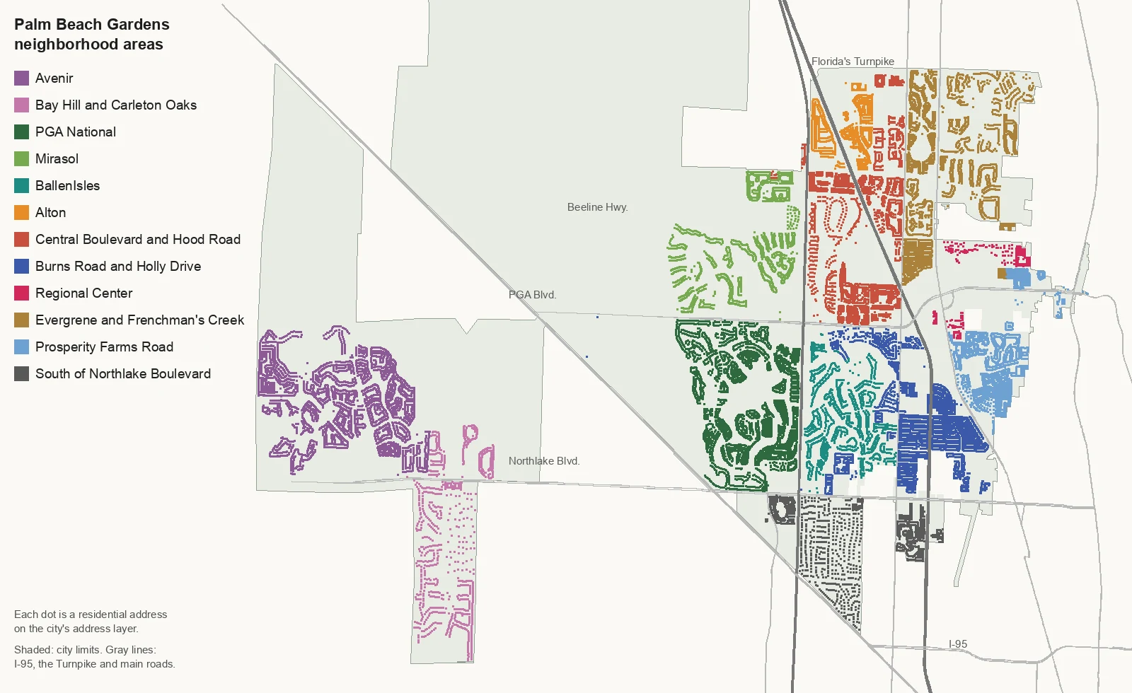
Map by Palm Beach Gardens Now from the City of Palm Beach Gardens’ address and boundary layers; roads © OpenStreetMap contributors.
The far west
Avenir is the city’s newest and largest community, 4,751 acres on the city’s subdivision layer, with about 4,100 homes north of Northlake Boulevard.
Bay Hill and Carleton Oaks are six small gated communities on Northlake Boulevard, about 1,000 homes, split between two high school zones.
The golf communities around the Turnpike
PGA National, 2,332 acres south of PGA Boulevard, is the city’s largest block of homes, about 5,400.
Mirasol, 2,302 acres north of PGA Boulevard, has about 2,200 homes and the city’s Mirasol Park.
BallenIsles, 1,300 acres between the Turnpike and Military Trail, has about 1,600 homes, most of them single-family houses.
North of PGA Boulevard
Alton, a 682-acre planned community, lies on both sides of I-95 between Hood Road and Donald Ross Road.
Central Boulevard and Hood Road take in Old Palm, Garden Lakes, Westwood Gardens, Paloma and about 15 more neighborhoods, around the city’s District Park.
Evergrene and Frenchman’s Creek, east of Military Trail, are mostly gated single-family communities, all zoned for Dwyer High.
The original city and the east side
Burns Road and Holly Drive cover the city’s original plats, City Hall and most of its neighborhood parks.
The Regional Center is the city’s name for the district around the Gardens Mall and Downtown at the Gardens, with about 3,100 homes, most of them condos.
Prosperity Farms Road runs through The Oaks, Siena Oaks and other communities east of Alternate A1A.
South of Northlake Boulevard covers Steeplechase, Garden Oaks, Gables at Northlake and five more neighborhoods.
Related guides
Property taxes, parks and trails, getting around, moving to Palm Beach Gardens and Palm Beach Gardens vs. Jupiter, Lake Park and North Palm Beach.
How we built this
The areas come from the City of Palm Beach Gardens’ own GIS layers, published on its map server: the subdivision layer, which names 24 larger communities such as PGA National, Mirasol, BallenIsles, Avenir, Alton and the Regional Center; the neighborhood layer, which names about 410 smaller neighborhoods and commercial centers; and the address layer, which gives each of the city’s 45,403 addresses a neighborhood, a ZIP code and a home type. Where the city names a large community, its page follows that boundary. The rest of the city’s named neighborhoods we grouped by the main roads between them (PGA Boulevard, Military Trail, Alternate A1A and Northlake Boulevard) and named each group for those roads or its largest communities; those pages say so. Overlays from the city’s Comprehensive Plan (the PGA Boulevard Corridor, the Northlake Boulevard Overlay Zone, the MacArthur Boulevard Historic Overlay and the Western Northlake Corridor Planning Area) are described on the pages they touch.
OpenStreetMap lists only one place name inside the city, Monet, a historic name near PGA Boulevard and Fairchild Gardens Avenue; we found no city source that uses it for a neighborhood, so it is not an area here. Every residential address was matched on Oct. 10, 2026, to the city’s layers and to Palm Beach County’s open data copy of the district’s attendance zones. The ZIP code list is the Census Bureau’s 2020 ZIP code relationship file.
Frequently asked questions
What are the neighborhoods of Palm Beach Gardens?
The city’s own map layers name about 410 neighborhoods and commercial centers and 24 larger communities. Our guide groups them into 12 areas: Avenir, Bay Hill and Carleton Oaks, PGA National, Mirasol, BallenIsles, Alton, Central Boulevard and Hood Road, Burns Road and Holly Drive, the Regional Center, Evergrene and Frenchman’s Creek, Prosperity Farms Road, and south of Northlake Boulevard.
What ZIP codes are in Palm Beach Gardens?
The Census Bureau counts four ZIP codes with at least a tenth of their land in the city: 33418, 33410, 33412 and 33403. On the city’s address layer, 49% of homes are in 33418, 35% in 33410 and 13% in 33412.
What high schools serve Palm Beach Gardens?
About 64% of the city’s homes are zoned for Palm Beach Gardens High and 34% for William T. Dwyer High, in Palm Beach County’s copy of the district’s zones. A few hundred homes in the far west are zoned for Seminole Ridge Community High.
Which Palm Beach Gardens ZIP code has the highest home values?
33412, at $835,049 in August 2026, according to the Zillow Home Value Index. The figure was $730,715 in 33418 and $589,714 in 33410.
Have your say